Tag: Conservation & Wildlife

  • Thermal imagery did not improve aerial culling rates overall

    What the study found

    Thermal cameras could detect feral deer under a range of temperatures and canopy densities, but they did not significantly increase overall culling rate compared with unaided visual shooting. The study suggests thermal imagery may be more useful when animal densities are lower and canopy cover is dense.

    Why the authors say this matters

    The authors conclude that selective use of thermal imagery in northern Australia could provide benefits in future culling programs. They also say further assessment is needed to optimize control practices.

    What the researchers tested

    The researchers compared thermal and conventional (unaided visual) approaches during aerial control of feral deer and pigs near Collinsville, Queensland, in a warm tropical climate. They analyzed video recordings from a chital deer control program to compare culling rates, animal detections, and search times.

    What worked and what didn't

    The thermal camera successfully detected animals across a variety of temperatures and canopy densities. However, it did not significantly increase the number of animals removed per hour or per kilometer compared with conventional detection, and there were no consistent differences in search time between the two approaches.

    What to keep in mind

    The available summary does not describe detailed limitations beyond the recommendation for further assessment. The findings are specific to a warm, tropical environment in northern Australia and to the conditions studied in this chital deer control program.

    • Thermal cameras detected animals across a range of temperatures and canopy densities.
    • Overall culling rate was not significantly higher with thermal detection than with conventional visual detection.
    • Search time did not show consistent differences between thermal and conventional runs.
    • The authors suggest thermal imagery may help more when animal density is lower and canopy cover is dense.
    • The study was based on video recordings from an aerial chital deer control program near Collinsville, Queensland.
  • Authors propose nine changes to biodiversity measurement

    What the study found

    The authors conclude that biodiversity measurement is undergoing rapid change and needs a radical transformation. They outline nine recommended changes for building more rigorous, resilient, and accessible biodiversity information systems.

    Why the authors say this matters

    The study suggests these changes matter because biodiversity measurement is fundamental for assessing environmental change, identifying priority areas for protection, judging whether actions are effective, and supporting decision-making for a sustainable planet. The authors also say new systems are needed to underpin policies and practices that maintain and restore ecological systems.

    What the researchers tested

    This is a perspective article, so it does not report a new experiment or dataset. The authors review recent advances in citizen science, image recognition, acoustic monitoring, environmental DNA, genomics, remote sensing, and AI, then use that overview to make recommendations.

    What worked and what didn't

    The authors say novel technologies offer exciting opportunities, especially for integrating data sources and filling data gaps. They also identify challenges, including the need for standard methods, calibration with existing data, safeguards against false or AI-hallucinated information, respect for Indigenous Knowledge, and resilience to technical and societal change.

    What to keep in mind

    This summary is based on a perspective article, not a report of original empirical results. The abstract does not provide evidence for the nine recommendations, and it does not describe specific limitations beyond the challenges the authors note.

    • The authors argue that biodiversity measurement needs a radical transformation.
    • They list nine recommended changes, including data integration, standard methods, and calibrated new technologies.
    • The abstract highlights citizen science, environmental DNA, genomics, remote sensing, and AI as important new tools.
    • The authors say trusted databases are needed to reduce the risk of false or AI-hallucinated information.
    • They also call for respectful incorporation of Indigenous Knowledge and more resilient global datasets.
  • Citizen science should help fill gaps in official statistics

    What the study found

    The authors argue that citizen science should take a more central role in official statistics. They say voluntary public data collection can help fill gaps left by lost or threatened survey capacity.

    Why the authors say this matters

    The authors say this matters because the termination of the Demographic and Health Surveys in February 2025 created a crisis for official statistics, especially in low- and middle-income countries without their own survey infrastructure. They also note that proposed U.S. Environmental Protection Agency cuts threaten the ability to monitor environmental sustainability and implement the SDGs, or Sustainable Development Goals.

    What the researchers tested

    This is a research article arguing for the role of citizen science in official statistics. The abstract describes the problem and makes a case for using data collected through voluntary public contributions, but it does not describe a new experiment or survey.

    What worked and what didn't

    The abstract states that citizen science can step up to help fill the gap in official statistics. It also says this approach now can and must play a more central role, but it does not report quantitative test results or compare it with other data sources.

    What to keep in mind

    The available summary does not provide detailed methods, data, or limitations. It also does not give evidence beyond the authors' stated argument about the need for citizen science.

    • The authors argue that citizen science should become more central to official statistics.
    • They describe the end of the Demographic and Health Surveys as a crisis for official data.
    • They say low- and middle-income countries are especially affected because many lack survey infrastructure.
    • They note that proposed U.S. EPA cuts could weaken environmental monitoring and SDG implementation.
    • The abstract does not report a new experiment or quantitative results.
  • Highway use was linked to different mammal responses in a conservation reserve

    What the study found

    The study found that a highway through a conservation reserve was associated with different responses among native medium-sized mammals. The strongest occupancy change was seen in the vulnerable parma wallaby, while some species showed small detection changes and one species was detected more often near the highway.

    Why the authors say this matters

    The authors conclude that an occupancy approach can be used to investigate wildlife responses to roads. The study suggests that further work is needed to better understand whether major roads through conservation reserves have an adverse influence on wildlife populations.

    What the researchers tested

    The researchers asked whether eight species of native mammals were influenced by a highway through a conservation reserve in north-east New South Wales, Australia. They used camera-trapping over 17 months at sites along the highway and at sites 0.5-10 km away along service roads through adjoining forest.

    What worked and what didn't

    Evidence for a highway response based on occupancy was strongest for the vulnerable parma wallaby, with occupancy rising from 0.5 at highway sites to 0.96 at sites more than 3 km into the forest interior. For the vulnerable long-nosed potoroo and the swamp wallaby, detection increased by 10% from the highway to the forest interior, but season or recent wildfire caused greater variation in detection. The mountain brushtail possum was detected more often near the highway than in the forest interior, and the endangered spotted-tailed quoll was detected at 80% of sites but too infrequently to assess its response well.

    What to keep in mind

    The abstract reports that some species were detected too infrequently to fully assess their response, including the spotted-tailed quoll. The available summary does not describe other limitations beyond the need for further studies.

    • The study examined eight native mammal species near a highway in a conservation reserve.
    • Parma wallaby occupancy increased from highway sites to forest-interior sites.
    • Long-nosed potoroo and swamp wallaby detection was slightly higher farther from the highway.
    • Mountain brushtail possum detection was higher near the highway than in the forest interior.
    • Spotted-tailed quolls were detected at many sites, but not often enough for a clear highway response.
  • Rural social networks shaped wildfire response in Sweden

    What the study found

    The study found strong evidence of social cohesion in rural communities during the 2018 Swedish wildfires, closely linked to place, history, and heritage. Informal and emerging groups, along with professionals in forestry and agriculture, were central to the local response.

    Why the authors say this matters

    The authors conclude that the findings bring local rural conditions to the fore and show the importance of timing, local networks, and skills in disaster response. The study suggests that focusing on resilience can also hide weak national preparedness and the denial or lack of recognition of rural resources and values.

    What the researchers tested

    The article examines local mobilisation in rural communities during the large and numerous wildfires in Swedish forests in 2018. It looks at how the crisis activated rural networks and resource mobilisation in a local context.

    What worked and what didn't

    Local networks, informal groups, and skilled people in forestry and agriculture were central to the response. The study also raises the question of whether resilience language can obscure broader problems, including limited national preparedness and an urban norm.

    What to keep in mind

    The abstract does not describe detailed methods, data sources, or specific limitations. The findings are presented as focused on rural communities in Sweden during the 2018 wildfire events.

    • Rural communities in Sweden mobilized local skills, networks, and resources during the 2018 wildfires.
    • Social cohesion was closely linked to place, history, and heritage.
    • Informal and emerging groups were central to the local response.
    • Professionals in forestry and agriculture also played an important role.
    • The authors question whether resilience language can hide weak national preparedness and an urban norm.
  • Framework links biodiversity monitoring to policy reporting

    What the study found

    The authors present the Biodiversity Monitoring Standards Framework (BMSF), a unified architecture for turning biodiversity observations into consistent, decision-relevant knowledge. They describe it as linking ethical principles, standardized data collection, accredited analytical workflows, and transparent reporting into a single auditable chain of evidence.

    Why the authors say this matters

    The study suggests this matters because achieving the Kunming-Montreal Global Biodiversity Framework requires monitoring systems that can convert heterogeneous observations into comparable indicators. The authors conclude that the framework could help locally generated data support credible policy reporting while maintaining data sovereignty for national agencies, Indigenous knowledge holders, local communities, and private-sector actors.

    What the researchers tested

    The article introduces the Biodiversity Monitoring Standards Framework and describes its tiered, federated design. It incorporates Essential Variables, accredited analytical methods, and open-source implementation pathways, and it includes a concrete application in a national forest-connectivity assessment.

    What worked and what didn't

    According to the abstract, the framework's novelty is its ability to connect the full chain from field observation to policy reporting, which existing standards do not do. The national forest-connectivity example is said to demonstrate improved reproducibility, transparency, and policy relevance relative to existing approaches.

    What to keep in mind

    The abstract does not describe detailed limitations, study size, or formal validation results. The claims are based on the framework description and a concrete application example, so the available summary does not show how broadly the approach has been tested.

    • The paper proposes a Biodiversity Monitoring Standards Framework for biodiversity monitoring.
    • The framework is designed to link ethical principles, data collection, analysis, and reporting.
    • The authors say it can support comparable indicators aligned with GBF targets.
    • A national forest-connectivity assessment is used as an example application.
    • The abstract says the example improved reproducibility, transparency, and policy relevance.
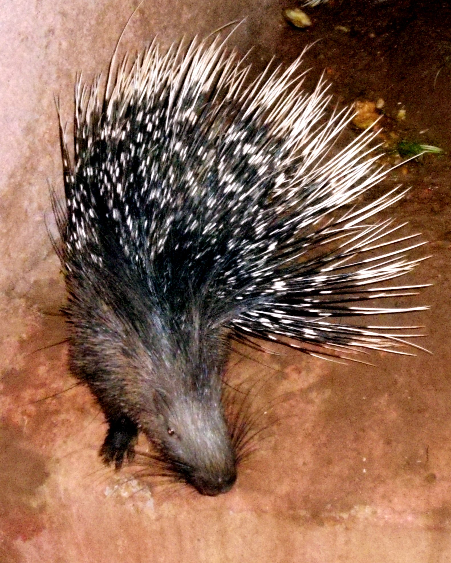
  • Porcupine density and behavior varied by season and habitat in Punjab

    Porcupine density and behavior varied by season and habitat in Punjab

    What the study found

    The study found that Indian crested porcupines in Punjab varied in density and behavior across habitats and seasons. It also found year-round reproduction and family-based parental care, with both sexes often caring for young together.

    Why the authors say this matters

    The authors conclude that the findings show the influence of seasonal and social factors on porcupine behavior. They also suggest the species is adaptable to diverse ecological conditions and that parental care in porcupine families is collaborative.

    What the researchers tested

    The researchers studied Indian crested porcupines, a rodent species, across diverse habitats in Punjab, Pakistan, from 2019 to 2021. They examined population density, spatial and temporal distribution, courtship behavior, reproductive ecology, and parental care dynamics.

    What worked and what didn't

    The median population density across surveyed sites was 3 individuals/km², with higher densities in irrigated forest plantations and sub-mountainous regions than in agricultural and desert ecosystems. Activity peaked in summer and was lowest in fall, and reproduction occurred year-round with peaks in February for singletons and in July for twins and triplets. Mounting and copulation were positively correlated, and parental care was most often performed by both males and females together; family patterns differed significantly (P < 0.001).

    What to keep in mind

    The abstract does not describe study limitations. The findings are limited to the surveyed habitats in Punjab, Pakistan, and the 2019–2021 study period.

    • Median porcupine density was 3 individuals/km² across surveyed sites.
    • Densities were higher in irrigated forest plantations and sub-mountainous regions than in agricultural and desert areas.
    • Porcupine activity peaked in summer and was lowest in fall.
    • Reproduction occurred year-round, with peaks in February and July.
    • Parental care was most often shared by both males and females together.